Are You Harnessing the Full Potential of Land-Surveying Technology?
Leveraging advanced land-surveying technology does wonders to improve work quality and efficiency. Seasoned and new land surveyors should capitalize on using the best tools to make precise measurements and accurate documentation. Not to mention, adapting to new technology is part of meeting clients’ changing needs and high expectations.
Benefits of Modern Land Surveying Technology
Getting behind the latest land-surveying technology should be a priority for surveying professionals who want to stay up to date with the industry. Surveyors can see the following results by leveraging high-tech land-surveying technology:
- Improved work efficiency
- Precise measurements
- Quick and easy recording
- Accurate scanning
- Reduced costs and work times
- Easy access to rugged terrains
- Improved safety
- More services to offer
- Improved client satisfaction
Types of Advanced Land Surveying Technology
The land surveying and mapping industry is going strong thanks to the growing demands of consumers and other sectors. In 2022, the global surveying and mapping services market was estimated at $33.5 billion, and it’s expected to grow to $46 billion by 2030.
Surveying companies must do their part to stay relevant and ride this growth wave while they can. They can do this by learning the latest trends in land-surveying technology. Being competitive in the current market will ensure business growth in the industry’s forecasted boom in the following years. Here are some technologies land surveyors should capitalize on.
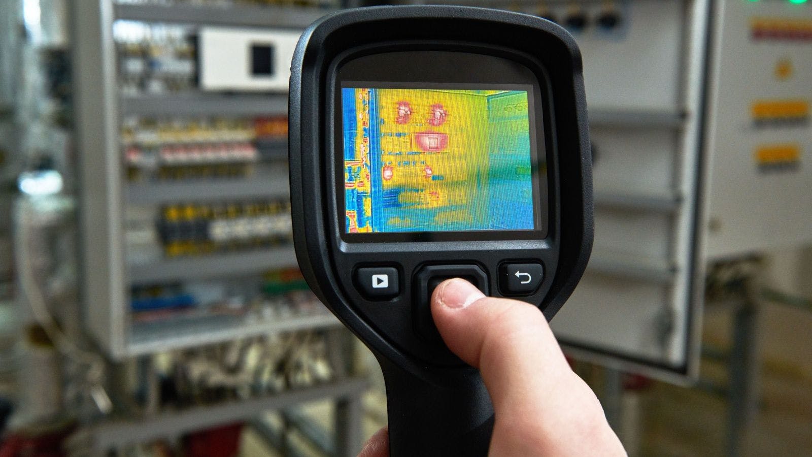
3D Scanning
3D scanners use advanced laser technology to check the interior of structures and create accurate models for study and other applications. The scanning can capture the spatial detail of a facility quickly and accurately. Light, imaging, detection and ranging technology is also used in 3D scanning to measure ranges and distances.
3D scanning is widely used in pre-construction surveys as it can confirm existing site conditions. Surveyors can use this data to create records, plans and models for future project phases.
Distance Measuring
Total station theodolites are one of the most essential tools in modern land surveying. This equipment gives surveyors improved accuracy, resulting in precise measurements. Its unique configuration allows solo operation via remote control.
This electronic distance measuring surveying tool measures distances with a laser for accurate calculation and recording. The onboard computer does complex calculations used in triangulation and data collection. EDMs can measure horizontal and vertical angles, slope distance and coordinates.
Some iterations of TSTs include robotic or motorized versions, providing added accuracy on the jobsite. Operators handle retroreflectors from an observed point while the TST measures and records data.
Drones or UAVs
Unmanned aerial vehicles and drones are now widely used in surveying. Their aerial capabilities allow surveyors to access rugged terrains and cover land surfaces from any point on a jobsite. Drones and UAVs have various applications, including:
- Topographic surveying: Locating 3D features of a property
- Mapping: Aerial photography for mapping properties
- Scanning: Used for 2D and 3D modeling
- Photogrammetry: Information collection using images
- Building surveying: Checking of building conditions and performance
- Environmental monitoring: For assessing ecological risks or conditions in and around a property
- Security surveying: Checking high-risk locations on a property or building site
Accessibility has always been a challenge in land surveying. High-tech drones make it safer for surveyors to map dangerous jobsites and help them take accurate measurements. Some drones have high-capacity batteries, allowing surveyors to cover large surface areas on extended flights if needed.
Another advantage of using drones is portability. Commercial drones for surveying are typically lightweight and compact. This feature makes it easy for surveyors to carry equipment from one site to another. The drone’s practical quality reduces fatigue and improves performance on the job.
Robotics
High-tech land surveying companies are also leveraging robotics in the field. Automation and robotics technology development has opened up new possibilities in land surveying. While drones and UAVs use the air to survey land and other objects, surveying robots traverse the ground to understand the terrain better.
Robotic surveyors can get accurate measurements even in the most challenging surroundings using laser scanners, sensors and other modern technologies. These robots can mark and record findings accurately using pre-programmed routes. Their sensors are also highly sensitive, able to pick up minute details along their path.
Surveying robots are a great supplement to a team of professional land surveyors. This technology will allow professionals to reach previously inaccessible and dangerous areas. Adopting this new surveying technology is a win-win for surveying companies and clients, as it reduces risk while improving work quality.
GPS
Global positioning systems are now more commonly used in land surveying. This technology allows surveyors to measure faraway objects from any point on the ground. They no longer need to climb high areas on a land plot to do a precise survey. With the help of GPS, surveyors can generate accurate readings using satellite-provided data.
GPS excels in providing accurate information and complete data for land surveying. It also makes land surveying possible in different environments and weather conditions.
Land surveyors utilizing GPS enjoy high accuracy by using 3D geographic information. This technology is flexible, consumes less time and is more effective than traditional surveying technology. Professionals using this technology must be highly trained to get the best results.
Leaning on Technology to Chart a Path to Success in Land Surveying
Companies and individuals in the land surveying industry should recognize the importance of upskilling and equipment proficiency to become key leaders in the field. While getting acquainted with new land-surveying technology and techniques can take some time, it’s a worthwhile investment that will pay dividends in the long run.
The construction industry is as strong as ever, especially with the boom in population and the demand for building structures. Land surveying will remain relevant and enjoy constant demand as more people buy and own homes, properties and other structures. Getting the right tools and training for the job are excellent ways to future-proof the profession and industry.


Related stories